Table of Contents
- The Red Sky That Stopped Western Australia in Its Tracks
- Why the Sky Turned Red Instead of Gray or Brown
- Cyclone Narelle Created the Perfect Setup
- A Rare Storm With an Unusual Track
- The Dust Was Beautiful, but It Was Also a Hazard
- Why the Images Spread So Fast Around the World
- What the Event Says About Western Australia’s Landscape
- What Happens After the Red Sky Fades
- A Red Sky That Was Both Warning and Wonder
The Red Sky That Stopped Western Australia in Its Tracks
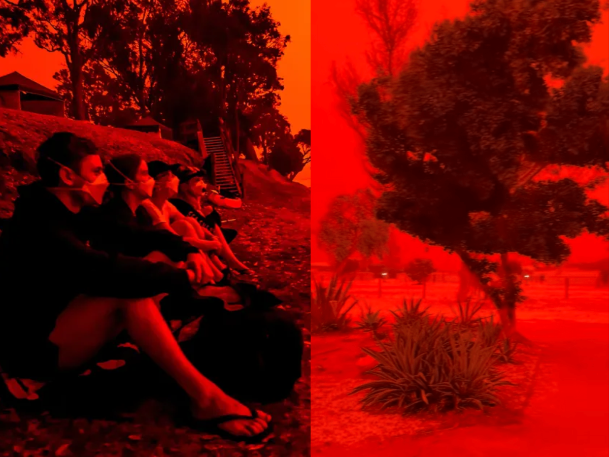
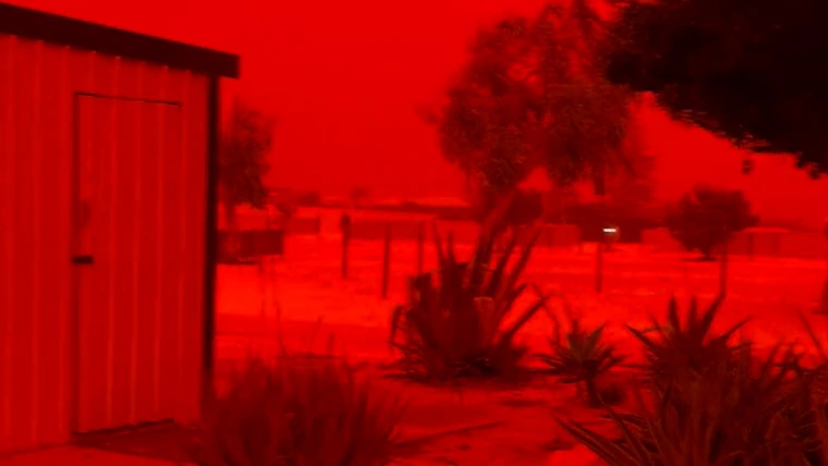
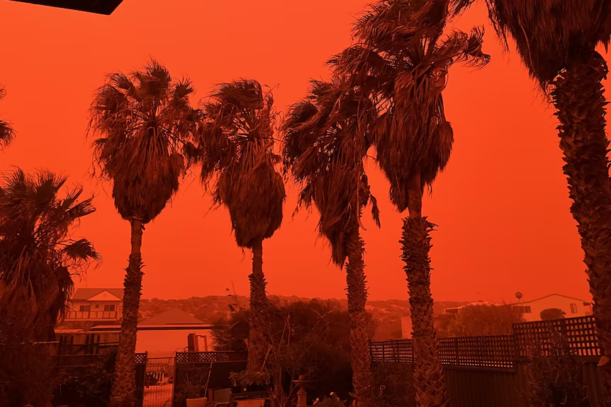
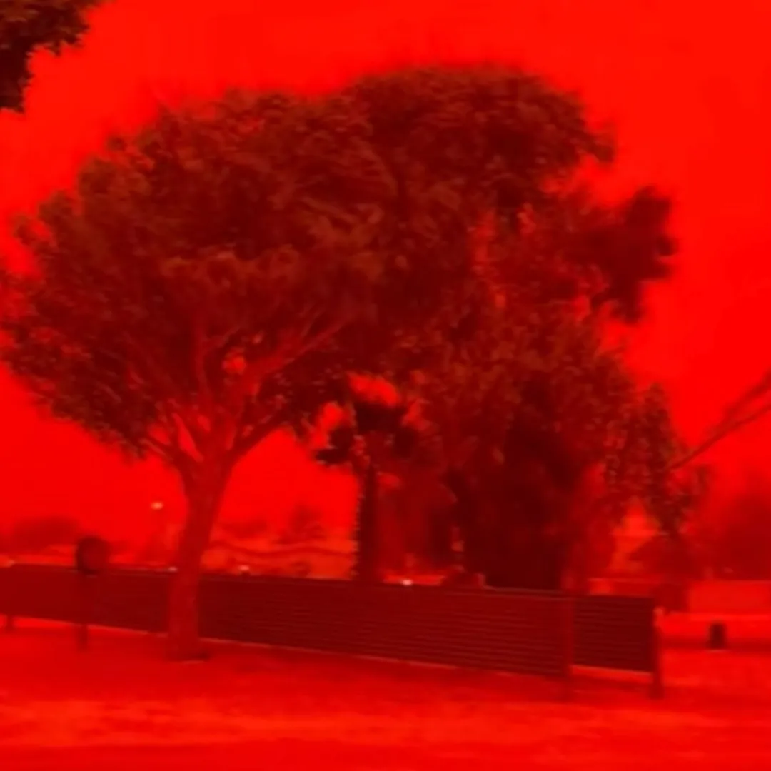
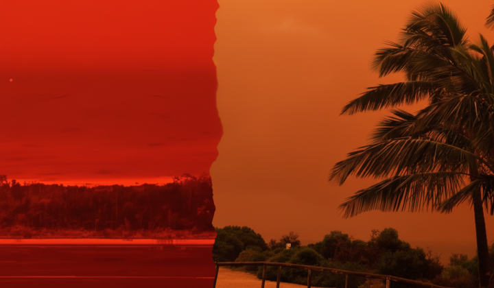
The most dramatic scenes were reported in Shark Bay, roughly 500 kilometres south of Exmouth, where the cyclone eventually made landfall farther north along the coast. ABC reported that residents in Shark Bay described the light as eerie and unforgettable, with the entire area cast in a thick red haze as dust moved through the atmosphere ahead of the system. The Guardian similarly reported that the sky turned a dramatic red before Narelle made landfall, and that the spectacle was tied to a dust storm formed by the storm’s approach.
The visual effect spread quickly online because it looked almost unreal. In photographs and videos, roads, homes, trees, and the horizon seemed submerged in an unnatural red filter. Yet the scene was not the result of camera tricks. It was the product of a weather system moving through one of the most iron-rich landscapes on Earth. According to meteorologists quoted by ABC and The Guardian, the cyclone’s winds swept up vast amounts of fine red dust from inland areas and carried it through the air, where it filtered the incoming sunlight and transformed the sky’s appearance.
Why the Sky Turned Red Instead of Gray or Brown
At first glance, it might seem obvious that a dust storm would simply make the sky hazy or dirty looking. But the reason this event became so visually dramatic lies in the color of the soil itself and in how light behaves when the atmosphere fills with particles. Western Australia’s dry inland soils are famously rich in iron oxide, the same chemical compound that gives rust its reddish color. When those tiny particles are lifted into the air in large quantities, they do not merely reduce visibility. They also alter the balance of light reaching the eye.
ABC explained that the fine dust created a filter effect, while meteorologists cited by The Guardian said the red color became especially intense because the material being lifted was iron-rich. Shorter wavelengths of light, particularly blue light, are more easily scattered away under these conditions, while the longer red and orange wavelengths become more visually dominant. The result was a sky that looked less like a standard dust storm and more like a strange, otherworldly sunset stretched across the entire day.
Cyclone Narelle Created the Perfect Setup
The red sky did not happen by chance. It emerged because Cyclone Narelle produced the exact kind of atmospheric conditions needed for this kind of spectacle. As the system approached the coast, strong winds moved across dry terrain, especially over dust-prone inland areas connected to the Pilbara and surrounding regions. The Guardian reported that this was essentially the perfect mix of dry conditions, strong wind, and iron-rich soil. ABC likewise said the approaching cyclone drove the dust into the air before residents in places such as Shark Bay saw the crimson effect settle over the region.
This also helps explain why the sky did not turn red everywhere in Western Australia with the same intensity. The effect depended on a very particular alignment of wind direction, dust availability, and viewing conditions. It was strongest where the dust load in the air was heaviest and where sunlight interacted with that suspended dust in just the right way. That is why some coastal communities reported especially dramatic skies while other areas experienced more ordinary storm conditions such as rain, wind, or low visibility without the same vivid crimson color.
A Rare Storm With an Unusual Track
Narelle was already notable even before the red sky footage began making headlines. The Guardian reported that the storm became the first system in more than two decades to make landfall across three different Australian states and territories. ABC’s live coverage also noted that by March 28 it had weakened to an ex-tropical cyclone or tropical low as it continued south through Western Australia, but the scale of its impacts and its unusual path made it one of the most closely watched weather events in the country this season.
That matters because it shows the red sky was part of a larger and more serious event, not just a visually unusual side story. Narelle brought destructive weather, heavy rain, and widespread disruption. News coverage reported that thousands were left without power in parts of Western Australia as the ex-cyclone continued south. Other reports said the storm affected shipping, port operations, and gas infrastructure, underscoring that the same system producing those remarkable images was also a major economic and logistical threat.
The Dust Was Beautiful, but It Was Also a Hazard
The surreal beauty of the event can make it easy to forget that thick airborne dust is not harmless. Fine dust reduces visibility on roads, interferes with outdoor work, and can worsen respiratory conditions, especially for people with asthma or other lung problems. While many residents were fascinated by the view, others were left cleaning layers of red dust from homes, vehicles, and public spaces after the storm moved on. The New York Post summary, while less authoritative than meteorological reporting, also described how dust covered surfaces across the affected areas even after the skies returned to normal.
The wider weather system also carried more serious dangers than the red sky itself. ABC reported ongoing power outages and storm impacts as the former cyclone tracked south. Reuters reported disruptions to Pilbara port terminals and operational interruptions affecting major mining and energy infrastructure. Another Reuters report said staff remobilisation was under way at the Waitsia gas plant after the storm affected operations. These consequences help place the spectacular sky in context. It was visually arresting, but it was also part of a storm event with real economic and safety implications.
Why the Images Spread So Fast Around the World
Part of what made this story explode online was its uncanny appearance. Weather events often go viral when they appear to violate people’s everyday expectations of nature. A bright blue sky, a storm cloud, or a sunset may be beautiful, but they are familiar. A coastline suddenly glowing dark red under a cyclone is something else entirely. ABC reported that the footage from Western Australia quickly made global headlines, and The Guardian framed the scene as one of the most visually dramatic parts of the cyclone’s approach.
There is also something culturally powerful about red skies. They are associated in popular imagination with warnings, omens, and disaster. That symbolic weight helped the images spread beyond weather circles into broader news coverage. Yet the science behind the spectacle is a useful reminder that nature often looks supernatural only because most people do not often see atmospheric physics play out on such a large and visible scale. In this case, there was no mystery beyond dust, light, and wind. But together, those ordinary ingredients created something unforgettable.
What the Event Says About Western Australia’s Landscape
This episode also drew attention to something distinctive about Western Australia itself. The region’s famous red earth is not just a scenic detail. It can shape the visual character of weather events when strong systems move through. The Pilbara in particular is globally known for iron ore and its mineral-rich terrain, and The Guardian noted that the dust likely came from iron-rich landscapes northeast of Denham. That geological backdrop is what made the cyclone’s dust plume so dramatically red rather than tan or gray.
In other words, the storm did not simply create a spectacle out of nowhere. It revealed the land through the sky. The color overhead reflected the color underfoot. That connection between landscape and atmosphere is part of what made the event feel so strange and so memorable. Residents were not just seeing a storm. They were seeing the region’s geology suspended above them, illuminated by sunlight and shaped by violent wind.
What Happens After the Red Sky Fades

By March 28, the Bureau of Meteorology said Narelle had weakened to an ex-tropical cyclone or tropical low as it moved south through Western Australia. But even after the most dramatic visual moments passed, the system continued to affect communities through wind, rain, outages, and recovery work. ABC’s live updates focused on the continuing hazards after the cyclone was downgraded, showing that the headline grabbing red sky was only one phase of a much longer weather story.
That is often the pattern with extreme weather. The images that capture the world’s attention tend to come at the height of the spectacle, but the real work begins afterward. Roads must be cleared, infrastructure checked, businesses reopened, and residents helped through cleanup and repair. Reuters’ reporting on port terminals and gas operations made clear that major industries in Western Australia were still dealing with the consequences even as the sky returned to a more familiar color.
A Red Sky That Was Both Warning and Wonder
In the end, the blood-red sky over Western Australia became global news because it was both beautiful and unsettling, a moment when the atmosphere looked almost cinematic while a very real cyclone moved closer to shore. The science behind it was not supernatural at all. It was the product of iron-rich dust, strong winds, and the physics of light scattering. Yet the emotional effect was powerful precisely because those forces combined in such an unusual and dramatic way.
Cyclone Narelle will likely be remembered for more than its landfalls, outages, and industrial disruption. It will also be remembered for that extraordinary sky, when Western Australia seemed to glow red beneath a storm and the internet briefly stopped to ask whether what people were seeing could possibly be real. It was real. And like many of nature’s most unforgettable moments, it was both a warning of the power of weather and a reminder of how astonishing the natural world can look when the atmosphere, the land, and the light align in exactly the wrong and right way at once.