Table of Contents
- A Storm That Grew Into a Serious Offshore Threat
- Why North Carolina Moved So Quickly
- Seven States Felt the Pressure
- The Storm Did Not Need Landfall to Become Costly
- The Science Behind Erin’s Danger
- Public Warnings Were Not Overreactions
- A Reminder About Hurricane Season Reality
- What Erin Still Says About Coastal Vulnerability
A Storm That Grew Into a Serious Offshore Threat
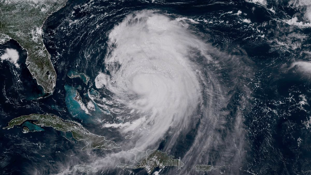
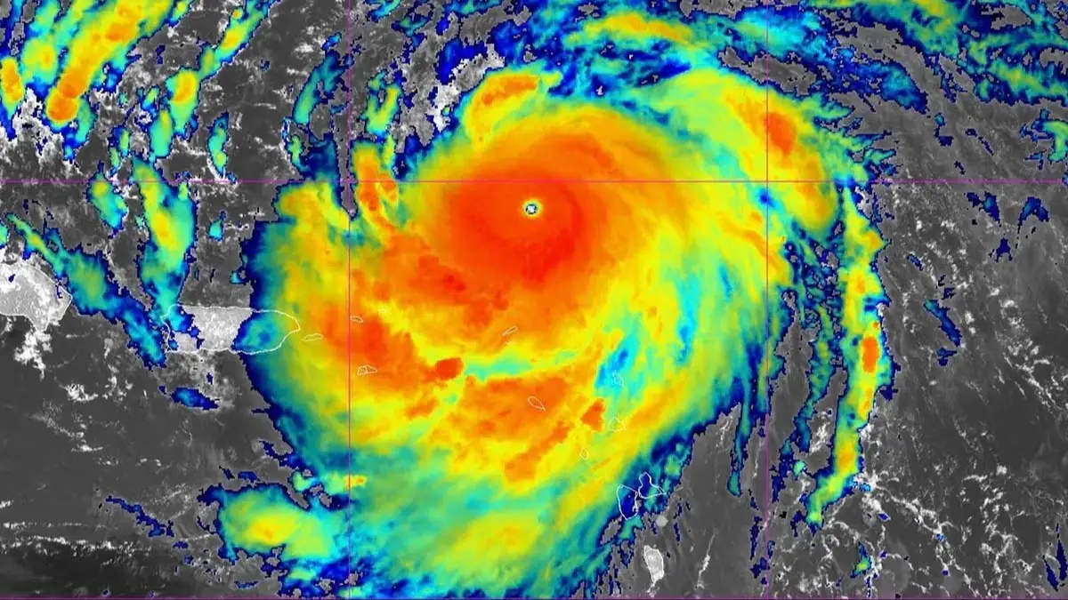
Hurricane Erin was not a weak or ordinary Atlantic system. NOAA described it as the first Atlantic hurricane of the 2025 season and noted that it rapidly intensified over the ocean as it moved toward the Caribbean and the U.S. Eastern Seaboard. At its peak, Erin reached Category 5 strength, making it one of the most powerful storms of that season even though it ultimately remained offshore of the continental United States. The National Hurricane Center’s archived advisories show Erin as a very large hurricane with maximum sustained winds around 130 mph as it churned through the western Atlantic, producing life-threatening surf and rip currents along the U.S. East Coast.
That combination made Erin especially dangerous. It was large, intense, and close enough to the coastline to generate serious coastal impacts without crossing onto land. This kind of setup can create public confusion. People often associate hurricane danger with the exact forecast cone or the location of the eye. But a storm like Erin shows why meteorologists repeatedly warn against focusing too narrowly on landfall. The center can stay offshore while the surf, swell, beach erosion, wind, flooding, and rip current threat still hit populated coastlines hard.
Why North Carolina Moved So Quickly
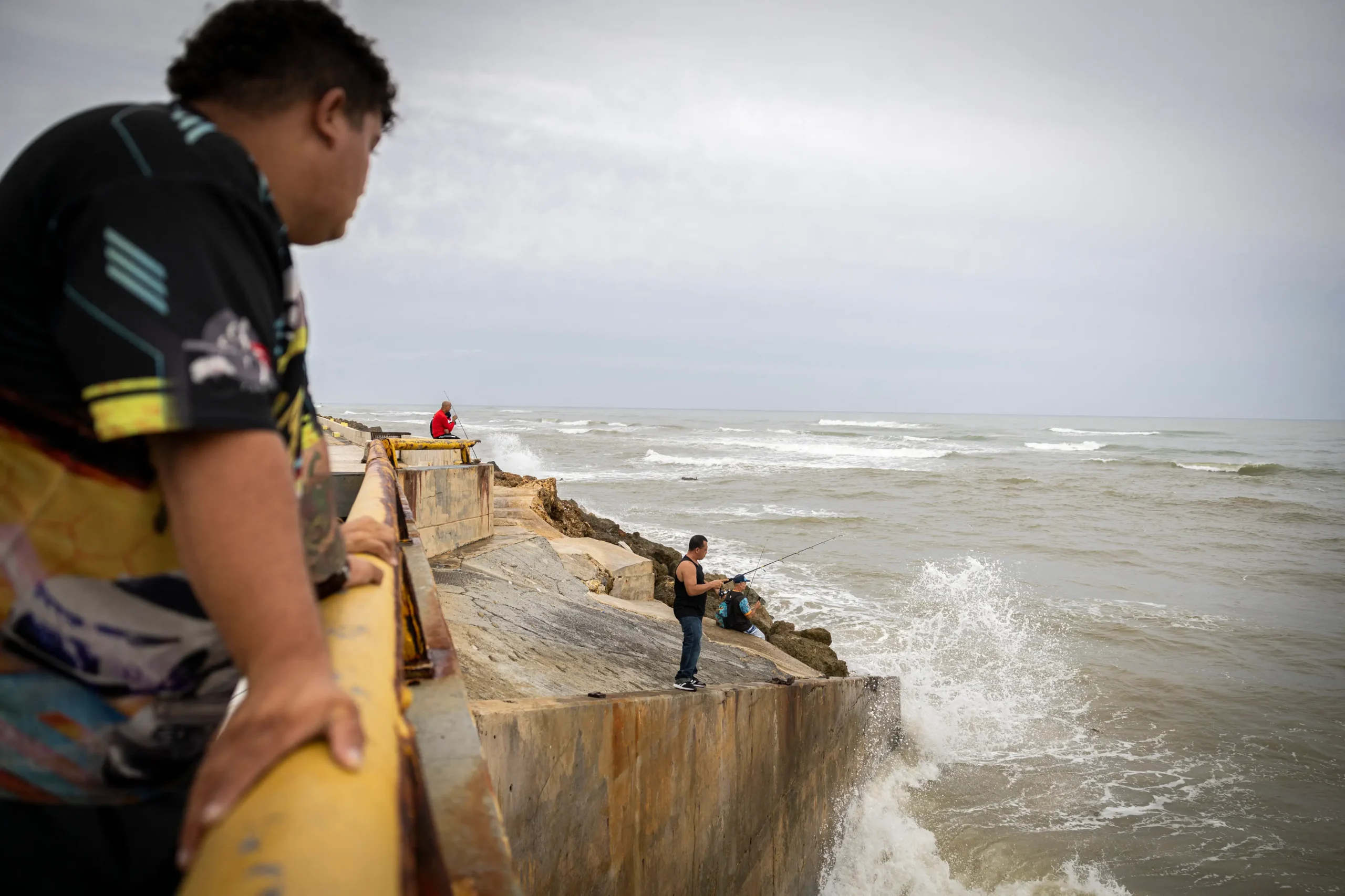
Nowhere was that lesson clearer than in North Carolina. Associated Press reporting from August 18, 2025 said Hurricane Erin forced evacuations on parts of the Outer Banks even though the storm was still expected to stay offshore. Mandatory evacuations were ordered on Hatteras Island and Ocracoke as officials warned that waves, coastal flooding, and tropical-storm-force conditions could make local roads impassable and place residents and tourists at risk. The AP reported that 15-foot surf and dangerous coastal flooding were among the major concerns for the low-lying barrier islands.
That response made sense given the geography of the Outer Banks. These narrow, exposed stretches of land are beautiful, heavily visited, and extremely vulnerable during hurricane season. Even a distant major hurricane can flood highways, isolate communities, and disrupt ferry access. Highway 12 in particular is a recurring point of concern because it serves as a fragile transportation lifeline across sections of the Outer Banks. When emergency managers look at a storm like Erin, they are not only watching wind speeds. They are asking how long roads remain passable, whether rising surf will cut off escape routes, and how quickly conditions could deteriorate for people staying behind.
The Dare County emergency page later documented evacuation bulletins and the staged reentry process after Erin moved away, further showing how seriously local officials treated the storm. These were not symbolic measures. They were practical steps taken because offshore hurricanes can still create life-threatening conditions long before people realize they are in danger.
Seven States Felt the Pressure
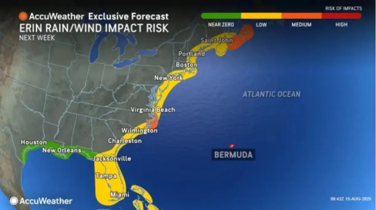
Although North Carolina carried the most visible evacuation story, Erin’s threat extended farther. Reporting around the storm described hazardous surf and rip currents along large portions of the Eastern Seaboard. The National Hurricane Center warned of life-threatening surf across the U.S. East Coast while Erin remained a very large hurricane. That meant the danger was not limited to one beach town or one state. Coastal areas from the Carolinas into the Mid-Atlantic and farther north had to prepare for rough seas, beach erosion, and water conditions that could turn deadly in moments.
The seven-state frame that appeared in some coverage reflected the storm’s unusually broad coastal footprint. North Carolina stood at the center of the most urgent action, but states farther north also had reason to worry because long-period swell can travel far from the storm’s center. That matters at the Jersey Shore, on Long Island, and in parts of southern New England, where dangerous surf and rip currents can overwhelm beach safety plans during the height of tourism season.
Even where local governments did not issue major evacuation orders, Erin still forced officials, lifeguards, and emergency managers to warn the public that the ocean itself had become the main hazard. A storm hundreds of miles away can still transform the shoreline into a danger zone, especially when it produces massive swell over several days rather than a brief period of bad weather.
The Storm Did Not Need Landfall to Become Costly
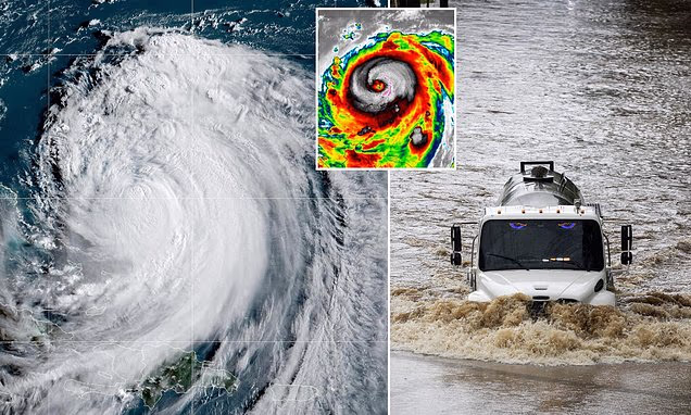
One of the most important truths about Erin is that staying offshore did not mean staying harmless. NOAA said the hurricane brought heavy rain and strong winds to coastal areas of Puerto Rico, the Turks and Caicos Islands, the Bahamas, and the U.S. Atlantic coast. The storm’s scale meant that its impact could ripple outward across several regions, affecting marine traffic, tourism, utility preparations, emergency operations, and coastal business activity.
For beach communities, even the threat of extreme surf can trigger lost revenue and abrupt disruption. Vacations are cut short. Ferries and small boats are halted. Ocean rescue concerns rise. Businesses that depend on summer foot traffic suddenly face closures or severe slowdowns. That is one reason storms like Erin can be so deceptive in economic terms. A direct landfall tends to dominate headlines, but an offshore giant can still inflict serious regional losses by shutting down the ordinary functioning of coastal life.
The AP’s reporting on tourists leaving the Outer Banks early captured that economic and emotional dimension. People did not wait around simply because the eye was forecast to remain offshore. Once mandatory evacuation language appeared, families changed plans, packed vehicles, and left vacation rentals behind. That reaction underscores how emergency messaging affects not only safety outcomes but also the rhythm of local economies built around seasonal travel.
The Science Behind Erin’s Danger
Erin was also an important storm from a meteorological perspective. NASA said the hurricane rapidly intensified over the Atlantic, and NOAA later used the storm to explain how distant hurricanes can still pose major threats to American coastal communities. That point is crucial. Many people hear the phrase “offshore storm” and assume the danger fades with distance. But hurricanes generate vast fields of wave energy, and their outer effects can travel far beyond the core of the storm.
Archived National Hurricane Center advisories show Erin going through eyewall replacement and re-intensification phases while remaining very large. That matters because storm size often influences the extent of coastal impacts just as much as peak intensity does. A compact hurricane can be violent but more concentrated. A very large hurricane can spread dangerous surf and water conditions across a much wider area.
This is also why Erin became a useful case study in how people misunderstand hurricane risk. Forecast maps are necessary, but they do not always communicate the full reach of water hazards. Swell, surf, rip currents, and coastal overwash can all hit communities that never appear close to the center line on a map. Erin’s 2025 track turned that idea from an abstract warning into a lived reality.
Public Warnings Were Not Overreactions
In hindsight, one of the striking features of the Erin story is how firm public warnings sounded before the storm’s worst East Coast effects arrived. Emergency managers in North Carolina did not hedge much. They pushed evacuation messaging. Forecast agencies stressed life-threatening surf. Officials treated the storm as a serious hazard despite the absence of an expected direct strike.
That approach reflects an important lesson in disaster communication. When a storm is large and conditions can change quickly, early action saves lives. Waiting for visual proof or last-minute certainty can be a costly mistake, especially on barrier islands where roads flood early and escape routes narrow fast. Erin’s case shows why public officials increasingly choose decisive messaging when offshore major hurricanes threaten exposed coastlines.
It also reveals the challenge of persuading residents and visitors to treat water hazards as real emergencies. For many people, the most dramatic hurricane images involve damaged homes and shattered buildings. But rip currents and high surf kill quietly. A storm does not need to topple a neighborhood to create lethal conditions. Erin’s surf threat was deadly precisely because it could tempt people to misjudge the ocean.
A Reminder About Hurricane Season Reality
There is also a broader seasonal lesson here. Erin arrived as the first hurricane of the 2025 Atlantic season and quickly demonstrated how fast risk can escalate. One storm can define the public’s understanding of an entire season, especially when it develops into a major hurricane early and threatens heavily populated coastlines. NOAA later used Erin as an example of how distant storms can endanger coastal communities, which suggests the storm had value not just as an event, but as a warning for future preparedness.
That lesson still matters now. Seasonal forecasts, preparedness campaigns, and public advisories often struggle against complacency. But Erin showed how quickly “not a direct hit” can turn into mandatory evacuations, road flooding, and coastwide water danger. Preparedness is not only about boarding windows when the eye is coming ashore. It is also about respecting ocean threats, following local orders, and understanding that a hurricane’s reach is often much wider than its headline path.
What Erin Still Says About Coastal Vulnerability
In the end, Hurricane Erin’s East Coast story was not about one catastrophic landfall. It was about widespread coastal vulnerability in an age when storms do not need to come ashore to become disruptive and dangerous. It was about how exposed barrier islands, beach economies, and emergency systems all respond when a powerful Atlantic hurricane spins just offshore with enough force to reshape the ocean for hundreds of miles. It was about the tension between distance and danger, and the way a map can sometimes look deceptively reassuring while the shoreline grows more dangerous by the hour.
For North Carolina, Erin meant evacuations and urgent warnings. For other coastal states, it meant battered beaches, dangerous water, and serious preparation. For forecasters, it became a strong example of why offshore storms still deserve public attention. And for everyone else, it offered a simple but important reminder: the Atlantic does not need to deliver a direct strike to put millions of people at risk. Sometimes the deadliest warning is not that a hurricane is coming straight at you, but that it is powerful enough to stay out at sea and still reach you anyway.